
C O N N E C T I O N S 2 : E XP L O R I N G I N T H E G E T T Y C E N T E R C O L L E C T I O N S, The Getty Center of the History of Art and the Humanities, Santa Monica, California, 1994
Curator: David Jensen
computer-generated images based on the maps of the Getty Center collections, steel, photographs, acrylic, Getty’s personal notes and memorabilia
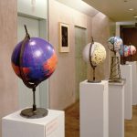
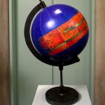
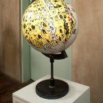
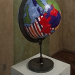
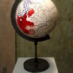
Mappa Mundi: Geo Politics Geo Art explored and reinterpreted the Getty Center’s collection in order to develop a discourse that questioned institutional authority. The installation consisted of five globes; each bearing a computer manipulated image taken from maps in the Getty Center’s collection.
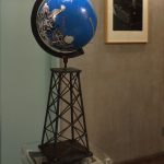
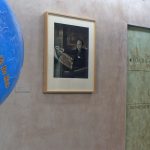
Four peripheral globes represented the ethnocentric, religious, and/or geopolitical views of the Roman Empire, the Christian Paradise, Napoleon’s Empire, and Hitler’s Third Reich, respectively.The centerpiece was a globe mounted on a miniature oil derrick with a computer-generated image based on a site plan of the new Getty Center, as designed by architect Richard Meyer. The oil derrick’s feet are resting on a pile of Getty’s personal notes and memorabilia found in the Getty Center collection. Behind the globe is a photograph, taken by Jousuf Karsh, of J.Paul Getty himself, opening a map.
The installation aimed to expose the global and authoritarian nature of ethnocentrism by comparing historical forms of national and cultural imperialism with Getty’s oil and art empires. The digital prints representing the five globes were purchased by the Getty Center and became part of their permanent collection.